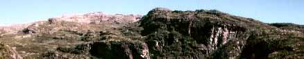
On 3 August we drove from Bergen for 2 hours to 600 m and carried another 2 hours to a charming lake at 850 m. Here we camped on a beach in ideal conditions, with a splendid sunset at 9.45. Next day we soon left the marked trail and were now truly in the wilderness (the area where Amundsen trained in winter for his South Pole expedition). At 1000 m we encountered a massive amount of snow which persisted for 4 days. The idea to climb the highest peak on the route (Vassfjora, 1633 m) had to be abandoned since one steep valley separated us from the upper slopes. It had been a hot day with only T-shirts being worn. We camped near a partially frozen lake at 1180 m on the only suitable site seen all day. To bypass the lake, we had to cross a crevassed area which turned out to be harmless.
On Day 3 I followed in the steps of my brother towards the 1633 m summit, whereas his 23 year-old son waited below with tender feet. It was an easy plod, mostly on snow, and again it became very hot. We spent a few minutes together at the summit before he ran down to walk out, reaching our cabin late that evening. Now I could enjoy the solitude of these wild parts. First I descended a little on the opposite side to a dramatic viewpoint directly down to a village in the Hardangerfjord. The music of cow bells from far below drifted up, like in a romantic play while I dozed and tried to take in the extensive panorama shimmering in the heat haze. The way down was punctuated by long rests which made a nice change from earlier exertions.
On Day 4 I set off in the general direction of the huge Hardanger Glacier which could occasionally be seen. However, I soon got stuck at some cliffs trying to descend into the next valley. So I had to back-track and try another way. This time I sneaked down a narrow passage and had to jump across a bergschrund with heavy pack in order to get on to a snow field. I was thankful for the ice axe on more than one occasion. Later I looked down on 4 reindeer running on the snow. By 2 p.m. I reached dry ground by a lovely lake sporting several icebergs, with a stream connected to two more lakes. The whole scene was quite magical and there was no way I could pass by such a beauty spot without setting up camp. In any case, the short hike had been trickier than anticipated. Now I enjoyed the luxury of a wash and also practiced fording the stream which flowed over smooth rock.
Next day progress was fast up firm slabs. I left the sack at the col and reached the summit (Osaskavlen, 1477 m) walking entirely on rock. However, the other side was completely covered by snow fields. I headed down easy slopes until the inevitable cliffs appeared. After several trials I began to think it impossible; then I spotted one way down which seemed tempting. However, a careful examination showed it to be a risky undertaking. Almost giving up the search, I found the very last possibility. Surprisingly, this consisted of grass ledges containing a variety of flowers. After a good rest, refreshed from a cool stream, I reached flat ground. Later I noticed a cabin at the end of a big lake. This made me think there was a dam which could save the trouble of wading a big river. Along the way I came upon 12 reindeer and hid behind a rock while they came close enough to take a picture. Several flocks of ptarmigan were also observed during the hikes. Unfortunately a river flowed out of the lake. Fording it proved an interesting challenge. The exceptionally hot summer combined with one of the heaviest snow falls conspired to make serious obstacles at the crossings and it was again good to use the ice axe for steadying myself. By 3 p.m. I pass by a tiny lake which looks so inviting I cannot resist stopping. Again the altitude is 1210 m and there is an iceberg in the middle. After a few mosquitos disappear at sunset I explore a small hill covered by heather and reindeer moss. During my contemplation a small lemen pops out from its burrow; the only one I encountered. The camp site is covered by soft 'mouse ear' which is Norway's smallest tree (< 1 cm!). I count my luck at having found two perfect sites when there are so few likely places at all since most level spots are either wet or rocky.
An easy hour's hike and river crossing on Day 6 brings me to the marked trail. Here I would have an escape route towards a railway station in case of bad weather. Near a big river crossing I see two campers getting ready. They don't notice me and I sneak round like a wild animal. The crossing is very wide and hence less formidable than it appeared at first. Now the trail is easy and I advance fast. However, further along I pass a cabin and can only see one trail continuing, marked by cairns, whereas a red T on rocks is expected. Scouting around, I fail to find an alternative and have no option but to follow this direction. An hour later I arrive at a big lake which is not supposed to be on the route. Fixing the position by my GPS, it becomes clear where I have ended up. But having forded the trickiest river of all, with slimy algae on smooth rock surfaces, I don't want to retreat. It turns out I can contour above the river and hit the proper trail some 2 km further up, and this strategy is successful. Later I face one more problem with a misleading signpost but choose the right path. By 4 p.m. I pass some abandoned pastures with cabins which are now used for skiing. The guardian greets me and I cannot avoid speaking to another human after 4 days silence. He warns of approaching rain and says there are 7 hours still to go. Now the trail comes within 1 km of the huge glacier I had been aiming for. First a small fast and very cold river must be crossed, then there is a bridge (my first) over a big branch. Here I encounter a few groups of twos and threes; then I am on my own again. There is a steep hill to get up (300 m gain), followed by gentle descent. Soon I have spectacular views down a desolate valley, with sheer clean rock on both sides. It is a most god-forsaken place, with a few abandoned homes. On getting down to another lake at 1000 m my map gives out and I don't realize the next map is in the pack. There follows an agonizing period of decision-making. Clearly the most famous waterfall in Norway cannot be situated in the sterile valley (the lake outlet is too small). The only other possibility is a steep climb which appears to lead back into the wilderness. However, logic prevails and I have no choice but to take the steep trail, my second, at the end of a long day. Powered by an energy bar and water I grind my way up 250 m. Fortunately several streams provide much needed cooling of my face and the mosquitos leave me alone as I get higher. There is a welcoming sight in the shape of a lake beyond the top. As luck would have it, I spot one little area for the tent, and am greatly relieved after 13 hours en route. It is even possible to eat supper at 11, somewhat delayed by the diminishing fuel supply, but I don't mind going without tea on the last morning (when the muesli and milk comes to an end).
On the last (7th) day it is a gentle 2 hours stroll to civilization but I see no suitable camp site along the way. Considering that daily 2000 people visit the upper waterfall viewpoint next to the hotel, it is amazing that not a single soul ventures upwards on the easy trail. After devouring freshly baked waffles with clotted cream and jam I walk down the old road and hike up the gorge to stand at the bottom of the waterfall which sends out a cool spray. It is the first time on the trip that the Goretex jacket is needed. I make it back to the crossroad in time to enjoy the last few shortbread biscuits before the bus comes and carries me down the valley. An hour later it starts raining and that day nearly an inch falls in Bergen. Given the fact that it also rained heavily 8 days earlier, luck was once more on my side, and the only problem was too much sunshine. But I am happy to have suffered such extreme conditions on my first expedition in Norway.
Sverre Aarseth